
1975~2015年董志塬土地利用/覆被变化及人类活动影响
Analysis of the spatial-temporal characteristics of LUCC from 1975 to 2015 in the Dongzhi loess tableland
-
摘要:
结合遥感、地理信息系统和数学方法,通过解译不同时间段(1975年、1995年和2015年)的土地利用数据,从土地利用变化速度、转移方向和土地利用程度3个方面分析了近40年来董志塬土地利用变化特征,揭示了1975年以来董志塬人类活动影响下土地利用时空变化规律。研究结果表明:1)1975~2015年期间,董志塬建设用地、林地、水域及水利设施用地的面积呈现总体上升的趋势;建设用地面积增加幅度最大,增加236.25 km2;其次是林地面积,增加158.68 km2;水域及水利设施用地面积增加幅度最小,增加2.06 km2。近40年来,耕地、草地和未利用地面积呈总体减少趋势。耕地面积与草地面积变化趋势相反,耕地面积呈现出"先增后减"的变化特点,共减少218.01 km2;草地面积则呈现"先减后增"的特点,共减少166.93 km2;未利用地面积呈现总体减少的趋势,共减少12.02 km2。2)近40年来,土地利用变迁主要集中在耕地、草地、建设用地和林地之间,草地和耕地之间变换频繁,是董志塬主要的土地利用变化类型。3)董志塬综合土地利用动态度从前20年(1975~1995年)的0.03增加到后20年(1995~2015年)的0.11,说明土地转化强度显著增强;但对于土地利用程度,董志塬前20年为正(0.051),后20年为负(-0.012),表明1995~2015年期间人类活动对土地资源起到正面保护的作用。
-
关键词:
- 董志塬 /
- 土地利用变化 /
- 人类活动 /
- 遥感影像 /
- 地理信息技术
Abstract:The Dongzhi loess tableland (34°50'~37°19'N, 106°14'~108°42'E) is the largest tableland on the Chinese Loess Plateau. However, the plateau surface of the Dongzhi tableland has suffered serious soil and water loss due to human activities. Land use change is an important indicator that reflects the impacts of human activities at regional scale. Therefore, the land use change of the Dongzhi tableland during the past 40 years (1975~2015) was characterized and the aim of this study was to quantify the dynamics of land use change and elucidate the impacts of human activities. In this study, the technologies of Remote Sensing (RS) and Geographical Information System (GIS) were applied and three imageries of remote sensing (1975, 1995 and 2015) were interpreted. Three indicators, including amplitude, direction and intensity of land use change, were used to characterize the dynamics of land use change and its driving forces. Results showed that:(1) Farmland and grassland were the main land use types on the Dongzhi tableland, which occupied more than 70% of the total land area. During the past 40 years, the area of construction land, forestland, water bodies and land for water conservation facilities exhibited an increasing trend, which increased by 236.25 km2, 158.68 km2 and 2.06 km2, respectively. The grassland showed a changing pattern of first decrease in 1975~1995 and then increase in 1995~2015, which ultimately decreased by 166.93 km2; whereas the farmland showed a changing pattern of first increase in 1975~1995 and then decrease in 1995~2015, which ultimately decreased by 218.01 km2. During the study period, the abandoned land showed a slight decrease of 12.02 km2. (2) The directions of land use change showed similar characteristics during the two periods of 1975~1995 and 1995~2015. The mutual conversions between farmland, grassland, construction land and forestland were the main features of land use change during the two periods of 1975~1995 and 1995~2015. However, the frequent exchange between grassland and construction land was the dominant form of land use change in the area. During 1975~1995, large area of grassland converted to farmland and construction land; while during 1995~2015, large area of farmland converted to grassland and forestland. Moreover, an area of farmland converted to urban during the time of 1995~2015. (3) The integration indicators of land use change increased from 0.03 during 1975~1995 to 0.11 during 1995~2015, which indicated that the intensity of land conversion significantly increased. During 1975~1995, the integration indicators of land use change showed positive values (0.051); while it showed negative value (-0.012) during 1995~2015, which indicate that human activities are changing to a conservation role in the land use change on the Dongzhi tableland.
-
Key words:
- Dongzhi loess tableland /
- land use change /
- human activities /
- remote sensing image /
- GIS
-

-
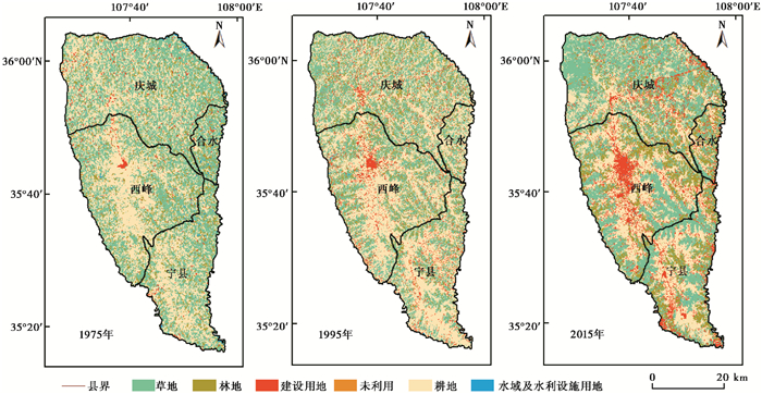
图 1
1975~2015年董志塬土地利用类型空间分布
Figure 1.
Land use and land cover change in the Dongzhi tableland during the time of 1975~2015
 下载:
全尺寸图片
幻灯片
下载:
全尺寸图片
幻灯片

图 2
1975~2015年董志塬土地利用变化分布
Figure 2.
The distribution of land use change in the Dongzhi tableland during the time of 1975~2015
下载:
全尺寸图片
幻灯片
表 1
1975~2015年董志塬遥感影像解译精度
Table 1.
Interpretation accuracy of the land use and cover change in the Dongzhi tableland during the time of 1975~2015
1975年 1995年 2015年 Overall Accuracy 0.89 0.90 0.94 KIA 0.87 0.88 0.92
下载: 导出CSV
表 2
土地利用程度分级赋值
Table 2.
Grading of the land use degree
生态系统类型 土地利用类型 分级指数 未利用土地级 未利用地或难用地 1 林、草、水用地级 林地、草地、水地 2 农业用地级 耕地、园地、人工草地 3 城镇聚落用建设用地级 城镇、居民点、工矿用地、交通用地 4
下载: 导出CSV
表 3
1975~2015年董志塬单一土地利用动态度
Table 3.
The rate of land use change in the Dongzhi tableland during the time of 1975~2015
土地利用类型 面积(km2) 单一土地利用动态度K(%) 1975年 1995年 2015年 1975~1995年 1995~2015年 1975~2015年 林地 262.62 277.99 421.30 0.29 2.58 1.51 草地 1219.15 952.71 1052.19 -1.09 0.52 -0.34 耕地 1228.40 1379.49 1010.38 0.62 -1.34 -0.44 建设用地 82.70 184.55 318.95 6.16 3.64 7.14 水域及水利设施 17.52 18.38 19.58 0.25 0.33 0.29 未利用地 28.77 26.03 16.75 -0.48 -0.89 -1.04
下载: 导出CSV
表 4
1975~2015年董志塬土地利用面积构成及变化
Table 4.
Area and percentage of land use types and dynamic change in the Dongzhi tableland during the time of 1975~2015
土地利用类型 各土地利用类型增减变化(km2) 面积百分比(%) 1975~1995年 1995~2015年 1975~2015年 1975年 1995年 2015年 林地 15.37 143.31 158.68 9.25 9.79 14.84 草地 -266.44 99.48 -166.93 42.94 33.56 37.06 耕地 151.10 -369.11 -218.01 43.27 48.59 35.59 建设用地 101.86 134.39 236.25 2.91 6.50 11.23 水域及水利设施 0.86 1.20 2.06 0.62 0.65 0.69 未利用地 -2.74 -9.28 -12.02 1.01 0.92 0.59 总计 0.00 0.00 0.00 100 100 100
下载: 导出CSV
表 5
1975~1995年董志塬土地利用类型转移矩阵(单位:km2)
Table 5.
Transition matrix of the land use types in the Dongzhi tableland between 1975 and 1995(km2)
土地利用类型 林地 草地 耕地 建设用地 水域及水利设施 未利用地 流域合计 转出面积 转出贡献率(%) 林地 259.71 0.76 1.80 0.17 0.00 0.18 262.62 2.92 0.88 草地 13.67 947.99 191.84 65.65 0.00 0.00 1219.15 271.16 81.58 耕地 3.34 2.55 1179.45 38.14 4.91 0.00 1228.40 48.94 14.72 建设用地 1.28 0.97 0.00 80.39 0.00 0.06 82.70 2.31 0.70 水域及水利设施 0.00 0.00 4.05 0.00 13.47 0.00 17.52 4.05 1.22 未利用地 0.00 0.43 2.35 0.21 0.00 25.78 28.77 2.99 0.90 流域合计 277.99 952.71 1379.49 184.55 18.38 26.03 2839.15 332.37 100 转入面积 18.29 4.72 200.04 104.17 4.91 0.25 332.37 转入贡献率(%) 5.50 1.42 60.18 31.34 1.48 0.08 100
下载: 导出CSV
表 6
1995~2015年董志塬土地利用类型转移矩阵(单位:km2)
Table 6.
Transition matrix of the land use types in the Dongzhi tableland between 1995 and 2015(km2)
土地利用类型 林地 草地 耕地 建设用地 水域及水利设施 未利用地 流域合计 转出面积 转出贡献率(%) 林地 231.36 6.65 0.24 39.75 0.00 0.00 277.99 46.64 6.92 草地 98.91 756.41 2.88 90.70 2.17 1.63 952.71 196.30 29.11 耕地 85.59 240.71 1005.62 45.27 2.10 0.19 1379.49 373.87 55.45 建设用地 5.44 33.67 0.78 142.96 0.33 1.38 184.55 41.59 6.17 水域及水利设施 0.00 3.09 0.32 0.00 14.98 0.00 18.38 3.40 0.50 未利用地 0.00 11.67 0.55 0.27 0.00 13.55 26.03 12.48 1.85 流域合计 421.30 1052.19 1010.38 318.95 19.58 16.75 2839.15 672.27 100 转入面积 189.94 295.78 4.76 175.98 4.61 3.20 672.27 转入贡献率(%) 28.17 43.87 0.71 26.10 0.68 0.47 100
下载: 导出CSV
表 7
董志塬1975~2015年土地利用程度变化
Table 7.
The degree of land use change in the Dongzhi tableland during the time of 1975~2015
1975 1995 2015 土地利用程度综合指数Lj 248.08 260.67 257.46 时段 1975~1995 1995~2015 1975~2015 土地利用程度变化率R 0.051 -0.012 0.038
下载: 导出CSV
-
[1] 符慧娟.基于遥感和GIS的内江市市中区耕地动态监测及驱动力分析[D].成都: 成都理工大学硕士论文, 2017: 2-12.
Fu Huijuan. Dynamic Monitoring and Driving Forces Analysis of Cultivated Land in Neijiang City Based on Remote Sensing and GIS[D]. Chengdu: The Master's Dissertation of Chengdu University of Technology, 2017: 2-12.
[2] Turner B, Lambin E F, Reenberg A, et al. The emergence of land change science for global environmental change and sustainability[J]. Proceedings of the National Academy of Sciences of the United States of America, 2007, 104(52):20666-20671. doi: 10.1073/pnas.0704119104
[3] Walker B. The terrestrial biosphere and global change:Implications for natural and managed ecosystems[J]. Quarterly Review of Biology, 1999, 400(6744):522-523. http://cn.bing.com/academic/profile?id=fc132c364efed6062a2dac5c4fcba617&encoded=0&v=paper_preview&mkt=zh-cn
[4] 郭斌.基于GIS的黄土高原南部土地景观动态及优化[D].西安: 陕西师范大学博士论文, 2011: 10-26.
Guo Bin. Land Landscape Dynamics and Optimization in Southern Loess Plateau Based on GIS[D]. Xi'an: The Ph.D Dissertation of Shaanxi Normal University, 2011: 10-26.
[5] 杨朔, 李世平.关中地区城市化过程中土地利用问题研究[J].中国土地科学, 2009, 23(7):79-81. doi: 10.3969/j.issn.1001-8158.2009.07.015
Yang Shuo, Li Shiping. Issues on land utilization during urbanization in Guanzhong region[J]. China Land Science, 2009, 23(7):79-81. doi: 10.3969/j.issn.1001-8158.2009.07.015
[6] 陈佑启, 杨鹏.国际上土地利用/土地覆盖变化研究的新进展[J].经济地理, 2001, (1):95-100. doi: 10.3969/j.issn.1000-8462.2001.01.022
Chen Youqi, Yang Peng. Recent progresses of international study on land use and land cover change(LUCC)[J]. Economic Geography. 2001, (1):95-100. doi: 10.3969/j.issn.1000-8462.2001.01.022
[7] 李旭亮, 杨礼箫, 田伟, 等.中国北方农牧交错带土地利用/覆盖变化研究综述[J].应用生态学报, 2018, 29(10):3487-3495. http://www.wanfangdata.com.cn/details/detail.do?_type=perio&id=yystxb201810040
Li Xuliang, Yang Lixiao, Tian Wei, et al. Land use and land cover change in agro-pastoral ecotone in Northern China:A review[J]. Chinese Journal of Applied Ecology, 2018, 29(10):3487-3495. http://www.wanfangdata.com.cn/details/detail.do?_type=perio&id=yystxb201810040
[8] Paudel B. Review of studies on land use and land cover change in Nepal[J]. Journal of Mountain Science, 2016, 13(4):643-660. doi: 10.1007/s11629-015-3604-9
[9] Yedage A H S. Analysis and simulation of land use/land cover change in the Quepem Tehsil Goa, India[J]. Journal of Advances in Remote Sensing and GIS, 2017, 5(1):67~76
[10] Verburg P H. A spatial explicit allocation procedure for modelling the pattern of land use change based upon actual land use[J]. Ecological Modelling, 1999, 116(1):45-61. doi: 10.1016/S0304-3800(98)00156-2
[11] Jenerette G D, Wu J. Analysis and simulation of land-use change in the central Arizona-Phoenix region, USA[J]. Landscape Ecology, 2001, 16(7):611-626. doi: 10.1023/A:1013170528551
[12] 彭建, 蔡运龙. LUCC框架下喀斯特地区土地利用/覆被变化研究现状与展望[J].中国土地科学, 2006, 20(5):25-31. http://www.wanfangdata.com.cn/details/detail.do?_type=perio&id=zhonggtdkx200605009
Peng Jian, Cai Yunlong. Study of karst land use/cover change under the framework of LUCC-Present and prospect[J]. China Land Science, 2006, 20(5):25-31. http://www.wanfangdata.com.cn/details/detail.do?_type=perio&id=zhonggtdkx200605009
[13] 刘纪远, 刘明亮, 庄大方, 等.中国近期土地利用变化的空间格局分析[J].中国科学:地球科学, 2002, 32(12):1031-1040. http://d.old.wanfangdata.com.cn/Periodical/zgkx-cd200212008
Liu Jiyuan, Liu Mingliang, Zhuang Dafang, et al. Spatial pattern analysis of recent land use change in China[J]. Science in China(Series D), 2002, 32(12):1031-1040. http://d.old.wanfangdata.com.cn/Periodical/zgkx-cd200212008
[14] 刘纪远, 布和·敖斯尔.中国土地利用变化现代过程时空特征的研究——基于卫星遥感数据[J].第四纪研究, 2000, 20(3):229-239. doi: 10.3321/j.issn:1001-7410.2000.03.003 http://www.dsjyj.com.cn/CN/abstract/abstract9461.shtml
Liu Jiyuan, Buhe Aosier. Study on spatial-temporal feature of modern land-use change in China:Using remote sensing techniques[J]. Quaternary Sciences, 2000, 20(3):229-239. doi: 10.3321/j.issn:1001-7410.2000.03.003 http://www.dsjyj.com.cn/CN/abstract/abstract9461.shtml
[15] 刘纪远, 张增祥, 徐新良, 等. 21世纪初中国土地利用变化的空间格局与驱动力分析[J].地理学报, 2009, 64(12):1411-1420. http://d.old.wanfangdata.com.cn/Periodical/dlxb200912001
Liu Jiyuan, Zhang Zengxiang, Xu Xinliang, et al. Spatial patterns and driving forces of land use change in China in the early 21st century[J]. Acta Geographica Sinica, 2009, 64(12):1411-1420. http://d.old.wanfangdata.com.cn/Periodical/dlxb200912001
[16] 李月臣, 宫鹏, 陈晋, 等.中国北方13省土地利用景观格局变化分析(1989-1999)[J].水土保持学报, 2005, (5):145-148. http://d.old.wanfangdata.com.cn/Periodical/trqsystbcxb200505036
Li Yuechen, Gong Peng, Chen Jin, et al. Landscape pattern and its dynamical change in North China during 1989-1999[J]. Journal of Soil and Water Conservation, 2005, (5):145-148. http://d.old.wanfangdata.com.cn/Periodical/trqsystbcxb200505036
[17] 吴琳娜, 杨胜天, 刘晓燕, 等. 1976年以来北洛河流域土地利用变化对人类活动程度的响应[J].地理学报, 2014, 69(1):54-63. http://www.wanfangdata.com.cn/details/detail.do?_type=perio&id=dlxb201401005
Wu Linna, Yang Shengtian, Liu Xiaoyan, et al. Response analysis of land use change to the degree of human activities in Beiluo River basin since 1976[J]. Acta Geographica Sinica, 2014, 69(1):54-63. http://www.wanfangdata.com.cn/details/detail.do?_type=perio&id=dlxb201401005
[18] 车小力.黄土高塬沟壑区董志塬沟头溯源侵蚀分布特征及其演化[D].杨凌: 西北农林科技大学硕士论文, 2012: 2-42.
Che Xiaoli. Study of the Distribution Characteristic and Evolution of Headward Erosion on Dongzhiyuan of Loess Gully Region[D]. Yangling: The Master's Dissertation of Northwest A & F University, 2012: 2-42.
[19] 史念海.历史时期黄土高原沟壑的演变[J].中国历史地理论丛, 1987, (2):3-54.
Shi Nianhai. Evolution of gully on Loess Plateau in historical period[J]. Journal of Chinese Historical Geography, 1987, (2):3-54.
[20] 陈绍宇, 许建民, 王文龙, 等.黄土高塬沟壑区董志塬沟头溯源侵蚀特征及其防治途径[J].水土保持通报, 2009, 29(4):37-41. http://www.wanfangdata.com.cn/details/detail.do?_type=perio&id=stbctb200904008
Chen Shaoyu, Xu Jianmin, Wang Wenlong, et al. Erosion features of head-cut and its control measures on Dongzhiyuan of the Loess Plateau[J]. Bulletin of Soil and Water Conservation, 2009, 29(4):37-41. http://www.wanfangdata.com.cn/details/detail.do?_type=perio&id=stbctb200904008
[21] 姚文波.历史时期董志塬地貌演变过程及其成因[D].西安: 陕西师范大学博士论文, 2009: 1-60.
Yao Wenbo. Geomorphological Evolution and Its Causes of Dongzhiyuan in Historical Period[D]. Xi'an: The Ph.D Dissertation of Shaanxi Normal University, 2009: 1-60.
[22] 陈绍宇, 许建民, 王文龙, 等.高塬沟壑区董志塬沟头溯源侵蚀典型调查研究[J].中国农学通报, 2009, 25(9):258-263. http://d.old.wanfangdata.com.cn/Periodical/zgnxtb200909055
Chen Shaoyu, Xu Jianmin, Wang Wenlong, et al. The research on erosional types and process of head-cut on Dongzhiyuan of Loess Plateau[J]. Chinese Agricultural Science Bulletin, 2009, 25(9):258-263. http://d.old.wanfangdata.com.cn/Periodical/zgnxtb200909055
[23] 安志鹏.庆阳市"固沟保塬"综合治理工程启动[J].党的建设, 2016, (4):54-54.
An Zhipeng. 'Retaining gully and protecting plateau' initiation of comprehensive treatment project in Qingyang City[J]. Dang De Jian She, 2016, (4):54-54.
[24] 郭明明.黄土高塬沟壑区退耕草地沟头溯源侵蚀及形态演化特征[D].杨凌: 西北农林科技大学硕士论文, 2016: 8-45.
Guo Mingming. Gully Headward Erosion and its Morphology Evolution Characteristics of Rehablitated Grass Land in the Gully Region of the Loess Plateau[D]. Yangling: The Master's Dissertation of Northwest A & F University, 2016: 8-45.
[25] 国土资源部.土地利用现状分类(GBT21010-2017)[S].北京: 中华人民共和国国土资源部, 2017: 1-7.
Ministry of Land and Resources of the People's Republic of China. Current Land Use Classification(GBT21010-2017)[S]. Beijing: Ministry of Land and Resources of the People's Republic of China, 2017: 1-7.
[26] 王秀兰, 包玉海.土地利用动态变化研究方法探讨[J].地理科学进展, 1999, 18(1):81-87. doi: 10.3969/j.issn.1007-6301.1999.01.012
Wang Xiulan, Bao Yuhai. Study on the methods of land use dynamic change research[J]. Progress in Geography, 1999, 18(1):81-87. doi: 10.3969/j.issn.1007-6301.1999.01.012
[27] 徐岚, 赵羿.利用马尔柯夫过程预测东陵区土地利用格局的变化[J].应用生态学报, 1993, 4(3):272-277. doi: 10.3321/j.issn:1001-9332.1993.03.001
Xu Lan, Zhao Yi. Forecast of land use pattern change in Dongling district of Shenyang:An application of Markov Process[J]. Chinese Journal of Applied Ecology, 1993, 4(3):272-277. doi: 10.3321/j.issn:1001-9332.1993.03.001
[28] 朱会义, 李秀彬.关于区域土地利用变化指数模型方法的讨论[J].地理学报, 2003, 58(5):643-650. doi: 10.3321/j.issn:0375-5444.2003.05.001
Zhu Huiyi, Li Xiubin. Discussion on the index method of regional land use change[J]. Acta Geographica Sinica, 2003, 58(5):643-650. doi: 10.3321/j.issn:0375-5444.2003.05.001
[29] 陈述彭, 童庆禧, 郭华东, 等.遥感信息机理研究[M].北京:科学出版社, 1998:346-368.
Chen Shupeng, Dong Qingxi, Guo Huadong, et al. Study on the Mechanism of Remote Sensing Information[M]. Beijing:Science Press, 1998:346-368.
[30] 刘纪远.国家资源环境遥感宏观调查与动态监测研究[J].遥感学报, 1997, 1(3):225-230. https://kns.cnki.net/KCMS/detail/detail.aspx?dbcode=CJFQ&dbname=CJFD9697&filename=YGXB199703010&v=MTg3Nzg3S1BDclRiTEt4RjliTXJJOUVaSVI4ZVgxTHV4WVM3RGgxVDNxVHJXTTFGckNVUkxPZVp1UnBGaURtVzc=
Liu Jiyuan. Research on Macro-survey and dynamic monitoring of national resources and environment by remote sensing[J]. Journal of Remote Sensing, 1997, 1(3):225-230. https://kns.cnki.net/KCMS/detail/detail.aspx?dbcode=CJFQ&dbname=CJFD9697&filename=YGXB199703010&v=MTg3Nzg3S1BDclRiTEt4RjliTXJJOUVaSVI4ZVgxTHV4WVM3RGgxVDNxVHJXTTFGckNVUkxPZVp1UnBGaURtVzc=
[31] 崔峰, 胡中生.庆阳市固沟保塬综合治理实施规划(2015-2020)[Z].兰州: 庆阳市水土保持管理局, 2014: 2-26.
Cui Feng, Hu Zhongsheng. A Plan for Gully Consolidation and Tableland Protection(GCTP)in Qingyang City(2015-2020)[Z]. Lanzhou: Soil Conservation Service of Qingyang City, 2014: 2-26.
[32] 董祚继.中国现代土地利用规划研究[D].南京: 南京农业大学博士论文, 2007: 1-17.
Dong Zuoji. Study on Modern Land Use Planning in China[D]. Nanjing: The Ph.D Dissertation of Nanjing Agricultural University, 2007: 1-17.
[33] 程磊, 徐宗学, 罗睿, 等.渭河流域1980-2000年LUCC时空变化特征及其驱动力分析[J].水土保持研究, 2009, 16(5):1-6. http://d.old.wanfangdata.com.cn/Periodical/stbcyj200905001
Cheng Lei, Xu Zongxue, Luo Rui, et al. Spatial-temporal characteristics of LUCC and driving factor analysis for Wei River basin from 1980 to 2000[J]. Research of Soil and Water Conservation, 2009, 16(5):1-6. http://d.old.wanfangdata.com.cn/Periodical/stbcyj200905001
[34] 王李婧, 邱临静, 吴一平, 等.渭河流域1980-2010年土地利用变化的时空异质性研究[J].第四纪研究, 2017, 37(6):1193-1203. http://www.dsjyj.com.cn/CN/abstract/abstract11400.shtml
Wang Lijing, Qiu Linjing, Wu Yiping, et al. Spatial-temporal heterogeneity of land use changes in the Wei River basin during 1980 and 2010 A.D.[J]. Quaternary Sciences, 2017, 37(6):1193-1203. http://www.dsjyj.com.cn/CN/abstract/abstract11400.shtml
[35] 张丽萍.基于协调度模型的西峰区土地利用程度评价研究[D].兰州: 甘肃农业大学硕士论文, 2012: 5-28.
Zhang Liping. Evaluation of Land Use Degree in Xifeng District Based on Coordination Degree Model[D]. Lanzhou: The Master's Dissertation of Gansu Agricultural University, 2012: 5-28.
[36] 曲青林.城市化背景下甘肃省土地利用程度分析[D].兰州: 甘肃农业大学硕士论文, 2009: 20-32.
Qu Qinglin. Land Use Degree in the Urbanization Area of Gansu Province[D]. Lanzhou: The Master's Dissertation of Gansu Agricultural University, 2009: 20-32.
[37] 刘多森.黄土高原近两千年来土地利用和环境的变迁[J].第四纪研究, 2004, 24(2):184-190. doi: 10.3321/j.issn:1001-7410.2004.02.008 http://www.dsjyj.com.cn/CN/abstract/abstract9115.shtml
Liu Duosen. The land use environment variation during the last 2000 years in the Loess Plateau[J]. Quaternary Sciences, 2004, 24(2):184-190. doi: 10.3321/j.issn:1001-7410.2004.02.008 http://www.dsjyj.com.cn/CN/abstract/abstract9115.shtml
[38] 李正国, 王仰麟, 吴健生, 等.不同土地利用方式对黄土高原植被覆盖季节变化的影响——以陕北延河流域为例[J].第四纪研究, 2005, 25(6):762-769. doi: 10.3321/j.issn:1001-7410.2005.06.012 http://www.dsjyj.com.cn/CN/abstract/abstract9043.shtml
Li Zhengguo, Wang Yanglin, Wu Jiansheng, et al. Impact on vegetation coverage seasonal change of different land use types in Loess Plateau:A case of Yanhe Basin[J]. Quaternary Sciences, 2005, 25(6):762-769. doi: 10.3321/j.issn:1001-7410.2005.06.012 http://www.dsjyj.com.cn/CN/abstract/abstract9043.shtml
[39] 谢宝妮.黄土高原近30年植被覆盖变化及其对气候变化的响应[D].杨凌: 西北农林科技大学博士论文, 2016: 10-22.
Xie Baoni. Vegetation Dynamics and Climate Change on the Loess Plateau, China: 1982-2014[D]. Yangling: The Ph.D Dissertation of Northwest A & F University, 2016: 10-22.
[40] 李志, 刘文兆, 王秋贤.黄土塬区不同地形部位和土地利用方式对土壤物理性质的影响[J].应用生态学报, 2008, 19(6):1303-1308. http://d.old.wanfangdata.com.cn/Periodical/yystxb200806021
Li Zhi, Liu Wenzhao, Wang Qiuxian. Effects of land use type and slope position on soil physical properties in loess tableland area[J]. Chinese Journal of Applied Ecology, 2008, 19(6):1303-1308. http://d.old.wanfangdata.com.cn/Periodical/yystxb200806021
[41] 赵宏飞, 何洪鸣, 白春昱, 等.黄土高原土地利用变化特征及其环境效应[J].中国土地科学, 2018, 32(7):49-57. http://d.old.wanfangdata.com.cn/Periodical/zhonggtdkx201807008
Zhao Hongfei, He Hongming, Bai Chunyu, et al. Spatial-temporal characteristics of land use change in the Loess Plateau and its environmental effects[J]. China Land Science, 2018, 32(7):49-57. http://d.old.wanfangdata.com.cn/Periodical/zhonggtdkx201807008
[42] 汤青, 徐勇, 刘毅.黄土高原地区土地利用动态变化的空间差异分析[J].干旱区资源与环境, 2010, 24(8):15-21. http://www.wanfangdata.com.cn/details/detail.do?_type=perio&id=ghqzyyhj201008004
Tang Qing, Xu Yong, Liu Yi. Spatial difference of land use change in Loess Plateau region[J]. Journal of Arid Land Resources and Environment, 2010, 24(8):15-21. http://www.wanfangdata.com.cn/details/detail.do?_type=perio&id=ghqzyyhj201008004
[43] 徐小任, 徐勇.黄土高原地区人类活动强度时空变化分析[J].地理研究, 2017, 36(4):661-672. http://d.old.wanfangdata.com.cn/Periodical/dlyj201704005
Xu Xiaoren, Xu Yong. Analysis of spatial-temporal variation of human activity intensity in Loess Plateau region[J]. Geographical Research, 2017, 36(4):661-672. http://d.old.wanfangdata.com.cn/Periodical/dlyj201704005
[44] 幸赞品, 颜长珍, 冯坤, 等. 1975-2015年宁夏生态系统格局宏观变化分析[J].生态学报, 2018, 38(22):7912-7920. http://d.old.wanfangdata.com.cn/Periodical/stxb201822004
Xing Zanpin, Yan Changzhen, Feng Kun, et al. Macro analysis of spatiotemporal variations in ecosystems from 1975 to 2015 in Ningxia Hui Autonomous Region of China[J]. Acta Ecologica Sinica, 2018, 38(22):7912-7920. http://d.old.wanfangdata.com.cn/Periodical/stxb201822004
[45] 马彩虹, 任志远.陕西黄土高原台塬区土地利用的人地关系透视[J].干旱区研究, 2015, 32(6):1240-1246. http://d.old.wanfangdata.com.cn/Periodical/ghqyj201506028
Ma Caihong, Ren Zhiyuan. Prospective of man-earth relationship of land-use in Shanxi Loess Tableland region[J]. Arid Zone Research, 2015, 32(6):1240-1246. http://d.old.wanfangdata.com.cn/Periodical/ghqyj201506028
[46] 李双双, 延军平, 万佳.近10年陕甘宁黄土高原区植被覆盖时空变化特征[J].地理学报, 2012, 67(7):98-108. http://d.old.wanfangdata.com.cn/Periodical/dlxb201207009
Li Shuangshuang, Yan Junping, Wan Jia. The spatial-temporal changes of vegetation restoration on Loess Plateau in Shaanxi-Gansu-Ningxia region[J]. Acta Geographica Sinica, 2012, 67(7):98-108. http://d.old.wanfangdata.com.cn/Periodical/dlxb201207009
-
 OSID
OSID
图(2)
表(7)
计量
- 文章访问数: 2021
- PDF下载数: 403
- 施引文献: 0