- Tours

- Premium
- App
- Ancestry DNA
- Free EBooks
- Magazine
Menu
User Menu


 Greek Mythology
 Norse Mythology
 Ancient Egypt
 Ancient Rome
 Ancient Mesopotamia


Active forum topics
- The Babel Texts
- Life, It only happened one time
- Egypt Street Views
- Bronze sword
- Which Culture Sparks Your Curiosity?
- Are you superstitious?
More
Greek Mythology
Norse Mythology
Ancient Egypt
Ancient Rome
Ancient Mesopotamia
Suggested Books

PARTNERS


![]()

Updated
15 June, 2015 - 21:40
Robin Whitlock
Hidden secrets revealed in 1491 world map that may have guided Columbus
- Read Later
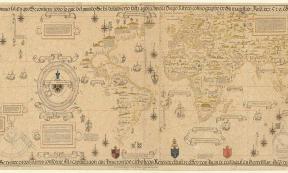
A map of the world produced in 1491 by Henricus Martellus has been subjected to multispectral imaging, which has revealed hidden details on the map not previously visible, including numerous Latin descriptions of regions and people.
Henricus Martellus is also known as Heinrich Hammer. He was a German cartographer who lived in Florence from 1480 to 1496. His 1491 world map is one of two (an earlier version was produced in 1489). It is similar to the terrestrial globe, called the Erdapfel, produced by the later mariner, artist, astronomer, philosopher and explorer Martin Behaim in 1492, which may actually have been influenced by Martellus. Both of these incorporate variations of the Ptolemaic model in that they show an opening to the Indian Ocean beneath the horn of Africa and they include the continent of Malaysia. Both may also derive from earlier maps produced by Bartolomeo Columbus, created around 1485 in Lisbon, Portugal. Some historians believe that the Martellus map may also have been used by Christopher Columbus prior to his voyage to circumnavigate the globe.

Martellus’ earlier map produced in 1489 ( Wikimedia Commons)
Not much is known about Martellus, but he probably lived in Nuremberg. His 1491 map, which has been preserved at the Beinecke Rare Book & Manuscript Library, may have been based on the work of Claudius Ptolemy, a Greek scholar who lived during the Second Century AD. Ptolemy’s writings on geography were generally unknown to Christian Europe but they formed the basis for the Renaissance in Geography. Martellus revised Ptolemy’s work from the information brought back by Marco Polo from his travels in Asia. He also incorporated information from voyages by Portuguese explorers to Africa.
- Hereford Mappa Mundi: Legendary Cities, Monstrous Races, and Curious Beasts in a Single World Map
- Phantom islands on ancient maps dismissed as mirages, myths, or mistakes
- Piri Reis Map - Evidence of Ancient Technology?

Martellus used information brought back by Marco Polo from his travels in Asia to compile his map. Marco Polo travelling, Miniature from the Book "The Travels of Marco Polo" ( Wikimedia Commons)
Multispectral imaging has helped to reveal details on the 1491 map that have previously been obscured by five centuries of fading and scuffing. The five-member team of researchers and imaging specialists that carried out the work visited the Beinecke Rare Book & Manuscript Library where the map has hung for years outside a reading room. A grant from the National Endowment for the Humanities enabled them to carry out work on the map which included photography of the map in 12 reflective colours. This included several frequencies that are beyond the range of visible light. The images were then analyzed with high-tech software.
“We've recovered more information than we dared to hope for” map historian and lead researcher Chet Van Duzer told Phys Org. Mr Van Duzer added that the images reveal numerous Latin descriptions of regions and peoples, including a text box over northern Asia which contains information about the people of ‘Balor’, revealing that they lived on a diet of venison. Another text describes the ‘Panotii’ people as having large ears, of such size that they could use them to sleep in. Van Duzer also discovered that Martellus used a manuscript version of Marco Polo’s travelogue, rather than the edition printed in Latin. Furthermore, Martellus based his depiction of southern Africa on Ptolemy’s Egyptus Novelo map, contained in three surviving manuscripts of his “Geography”. This map was itself constructed on the basis of information from native Africans, rather than European explorations but this area of Martellus’ map was probably produced from information revealed by Ethiopian delegates to the Council of Florence in 1441. The fact that Martellus map shows Africa extending further eastward than the known versions of the Egyptus Novelo means that he must have been using a more complete version that displayed Africa’s eastern coast.
The new images are important in that they reveal how the Martellus map influenced later map-makers, such as that produced by German cartographer Martin Waldseemüller in 1507, which was the first map to label the New World as ‘America’. Texts on the Martellus map show that it was an important source for Waldseemüller. “It puts you in the mapmaker's workshop” Van Duzer said. “It's easy to imagine Waldseemüller at his desk consulting various sources.”

World Map Universalis Cosmographia, 1507; by German Cartographer Martin Waldseemüller ( Wikimedia Commons)
Interestingly, the image of Japan on the map is completely wrong. It is mentioned in the map’s text as being around 1,000 miles away from the coast of Asia. This in turn may have led Christopher Columbus to believe he had found Japan when actually he had arrived in the Bahamas.
According to Professor Roger Easton of the Chester F. Carlson Center for Imaging Science at Rochester Institute of Technology, new discoveries are still being made and that, so far, about 80 percent of the text on the map has now been revealed. The research team is currently focusing on Java. Once the work is complete, the images will be presented to academics and the public via the Beinecke Library website.
Featured image: The Yale world map of "Henricus Martellus Germanus" (Heinrich Hammer). It is the most detailed "Dragon Tail" map by Martellus. It is the only one with a coordinate grid. ( Wikimedia Commons)
By Robin Whitlock

Related Articles on Ancient-Origins
31 March, 2024 - 17:29
Robbie Mitchell
History of Maps: From Ancient Artifacts to Modern Marvels
The history of cartography traces humanity's relentless quest to understand and depict the world around us. From ancient civilizations sketching rudimentary maps to modern digital cartography, this...
- Read Later
- Read more about History of Maps: From Ancient Artifacts to Modern Marvels
11 August, 2023 - 15:00
Gary Manners
Huge New Prehistoric Sites Database Transforms Understanding of Human History
In another step towards unraveling the intricate tapestry of human history, a huge database of prehistoric sites spanning a history from 3 million to 20,000 years ago has been unveiled. This...
- Read Later
- Read more about Huge New Prehistoric Sites Database Transforms Understanding of Human History
27 June, 2023 - 01:53
Robbie Mitchell
How Leonardo da Vinci Made a "Satellite" Map in 1502 (Video)
In 1502, while working as a military engineer for Cesare Borgia , Leonardo da Vinci undertook the task of creating a unique map of Imola. At the time, the prevailing maps were depicted in a birds eye...
- Read Later
- Read more about How Leonardo da Vinci Made a "Satellite" Map in 1502 (Video)

23 January, 2023 - 17:58
Robbie Mitchell
7 Phantom Islands We Never Really Discovered
The Earth is a big place, and it has taken us a long, long time to fully map it. Today, it is easy to feel like the last of the great adventures is over, and we’ve found all that there is to be found...
- Read Later
- Read more about 7 Phantom Islands We Never Really Discovered

10 December, 2021 - 17:59
ashley cowie
Archaeology Magazine’s Top Ten Archaeological Discoveries 2021
The top 10 ancient discoveries for 2021 have been announced by Archaeology Magazine . For the last 70 years Archaeology Magazine has been published by the Archaeological Institute of America and this...
- Read Later
- Read more about Archaeology Magazine’s Top Ten Archaeological Discoveries 2021

8 September, 2021 - 01:53
Christos Djonis
The Legendary Hyperborea and the Ancient Greeks: Who Really Discovered America?
In his story of Atlantis, written at around 360 BC, Plato mentioned a grand island or continent across the Atlantic, one larger than Libya and Asia combined. This continent was so enormous, he said...
- Read Later
- Read more about The Legendary Hyperborea and the Ancient Greeks: Who Really Discovered America?
Comments
It's interesting that japan would have been thought to have been so distant from Asia. In one of the earliest mentions of the archipelago, the Chinese report Gishi Wajinden, also mentioned japan as being far more distant than it really is. I wonder if these reports were taken directly or indirectly from these reports.
Be part of the movement that just ignores Columbus because he was a insignificant no body, and by far NOT the first.
misleading title